Maps Connecting Your Group
Our application allows members of a private Be-Maps Group to securely share: current locations (with location history), GeoShapes, activities and safety-related information directly between their own devices.
Designed for families, friends and other trusted groups, Be-Maps combines private location sharing with intelligent map features that help people stay connected, coordinate everyday life and improve personal safety.
Unlike many location sharing applications, Be-Maps is designed with privacy in mind. Shared information belongs to your private Be-Maps Group and remains under your control.
What Can Be-Maps Share?
All shared information is displayed on the map, giving authorised group members a complete picture of current and historical activity.
Location sharing can be turned off fully or for 2h, data sharing has to be enabled for trusted devices, for full monitoring Be-Maps application needs to be showing always-on monitoring screen.
Please note: you can send a delete request to your Be-Maps Group to delete data for a specific device (these will be deleted during that device charging).
Members of a private Be-Maps Group can securely share:
| Be-Maps Feature |
Available |
Can be turned off |
Configurable |
| Location Sharing |
✔ Yes |
✔ Yes |
✘ No |
| Geo-Fencing (GeoShapes) |
✔ Yes |
✔ Yes |
✔ Yes |
| Proximity (Distance Alerts) |
✔ Yes |
✔ Yes |
✔ Yes |
| Shared Activities |
✔ Yes |
✔ Yes |
✘ No |
| Alerts & Notifications |
✔ Yes |
✔ Yes |
✔ Yes |
| Captured Photos, Voice & Video |
✔ Yes |
✔ Yes |
✔ Yes |
| Visit Reminders |
✔ Yes |
✔ Yes |
✔ Yes |
| Monitoring information |
✔ Yes |
✔ Yes |
✔ Yes |
| Approved Devices |
✔ Yes |
✔ Yes |
✔ Yes |
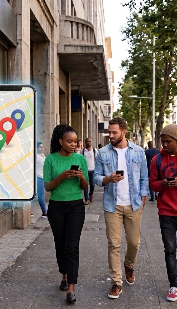
Private Location Sharing
Location sharing is one of the core features of Be-Maps.
Many safety and automation features rely on accurate location updates, so location permission is required for the application to function correctly.
You remain in control of your privacy. Depending on the selected data-sharing mode, location sharing can be temporarily suspended or switched to View Only mode whenever required.
Current Location
Members of your private Be-Maps Group can view each other's current location and location history directly on the shared map.
This makes it easy to know when someone is on the way, has arrived safely or may need assistance.
Shared Events
Be-Maps allows authorised group members to securely exchange location-based information, including:
• Alerts
• Messages
• Alert photos
• Voice recordings
• Video recordings
Every shared event is linked to its location, making it easier to understand what happened and where.
Google Maps Navigation
Any shared Be-Maps location can be opened directly in Google Maps for turn-by-turn navigation.
The selected destination is also copied to the clipboard, making it quick to forward to another person or to emergency services when needed.
Location History
Be-Maps can store location history for up to 180 days.
Historical locations are displayed together with activities and events, making it easy to review previous journeys or reconstruct past situations.
GeoShapes (Advanced Geofences)
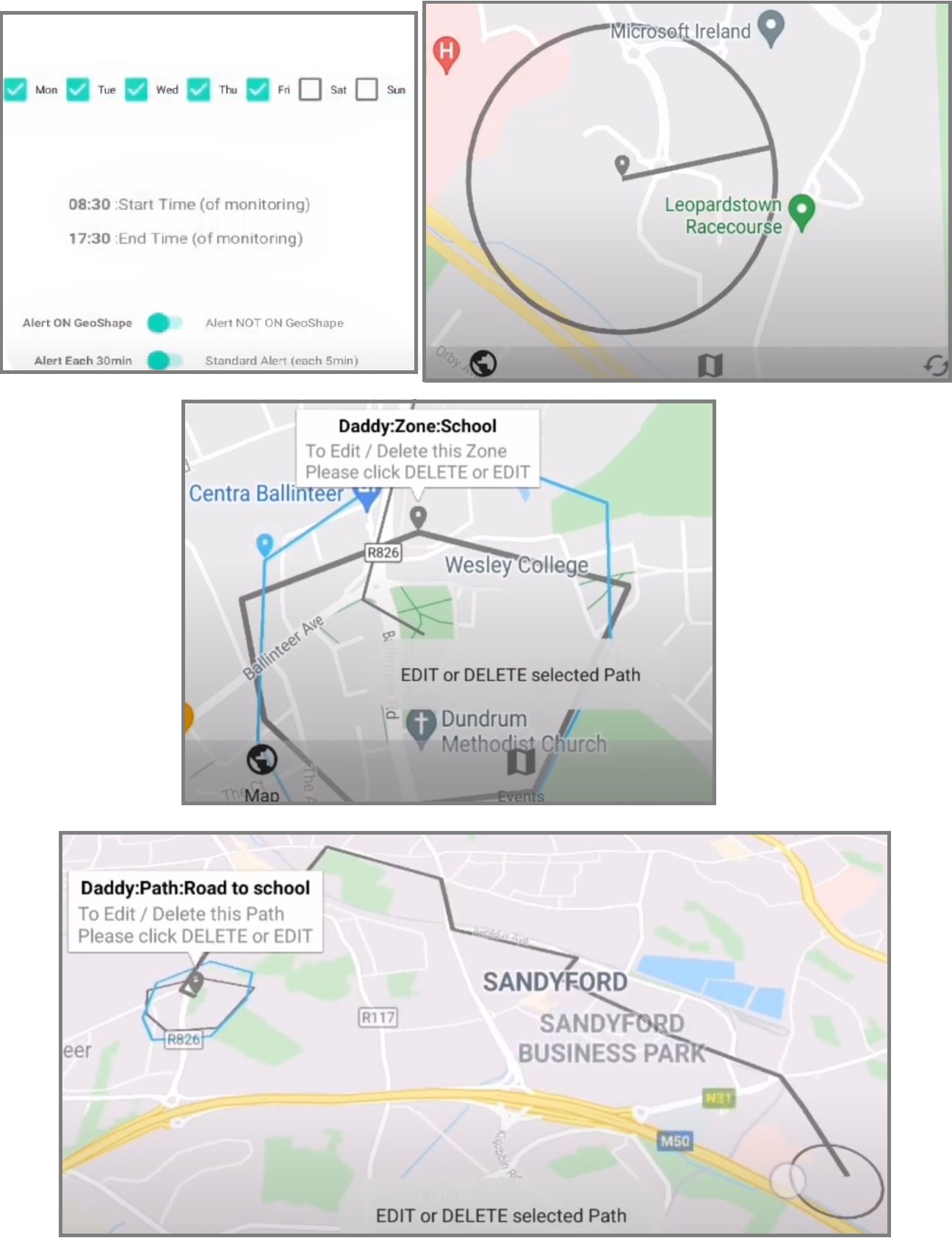
GeoShapes are intelligent geofences that monitor important places, areas and routes.
They help members of a private Be-Maps Group stay informed when someone arrives, leaves or travels through important locations.
Be-Maps supports three GeoShape types:
• Place - a circular area
• Zone - a custom polygon
• Path - a route drawn as a polyline
GeoShapes can be assigned to yourself or another member of your private group.
Typical examples include:
• Home
• School
• Workplace
• Shopping centres
• Sports clubs
• Holiday accommodation
• Routes to school
• Custom safety zones
When a GeoShape event occurs, Be-Maps generates spoken and visual notifications and records the event on the shared map.
GeoShape monitoring continues even when the application is running in the background.
To support this functionality, Be-Maps requires background location permission. When your device asks for location access, choose Always Allow so GeoShape monitoring can continue operating correctly.
Proximity Alerts
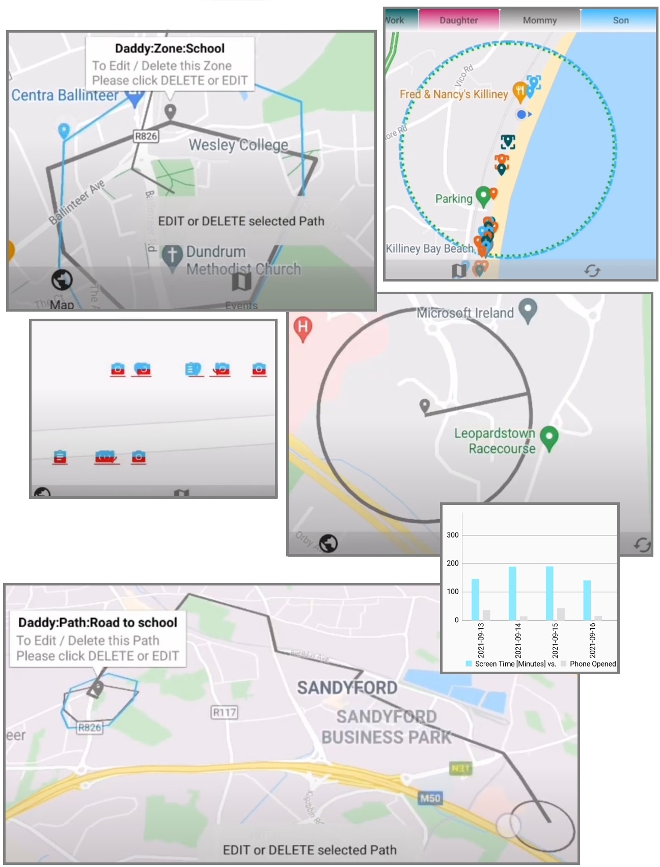
Proximity Alerts monitor the changing distance between members of your private Be-Maps Group.
Instead of repeatedly checking the map, you can simply let Be-Maps notify you.
Two types of proximity monitoring are available.
Visit Proximity
Create a reminder for an important location such as a supermarket, pharmacy or other place you want someone to visit.
When the selected person enters that area, Be-Maps generates a spoken reminder on their device.
Visit Proximity can be configured for yourself or another member of your private group.
Dynamic Proximity
Dynamic Proximity continuously monitors the distance between two members.
Examples include:
• Notify me when someone is nearby.
• Notify me when someone moves too far away.
• Notify me when my child leaves the allowed area.
• Notify me when someone arrives close to home.
These intelligent notifications help families coordinate everyday activities without constantly watching the map.
Shared Activities
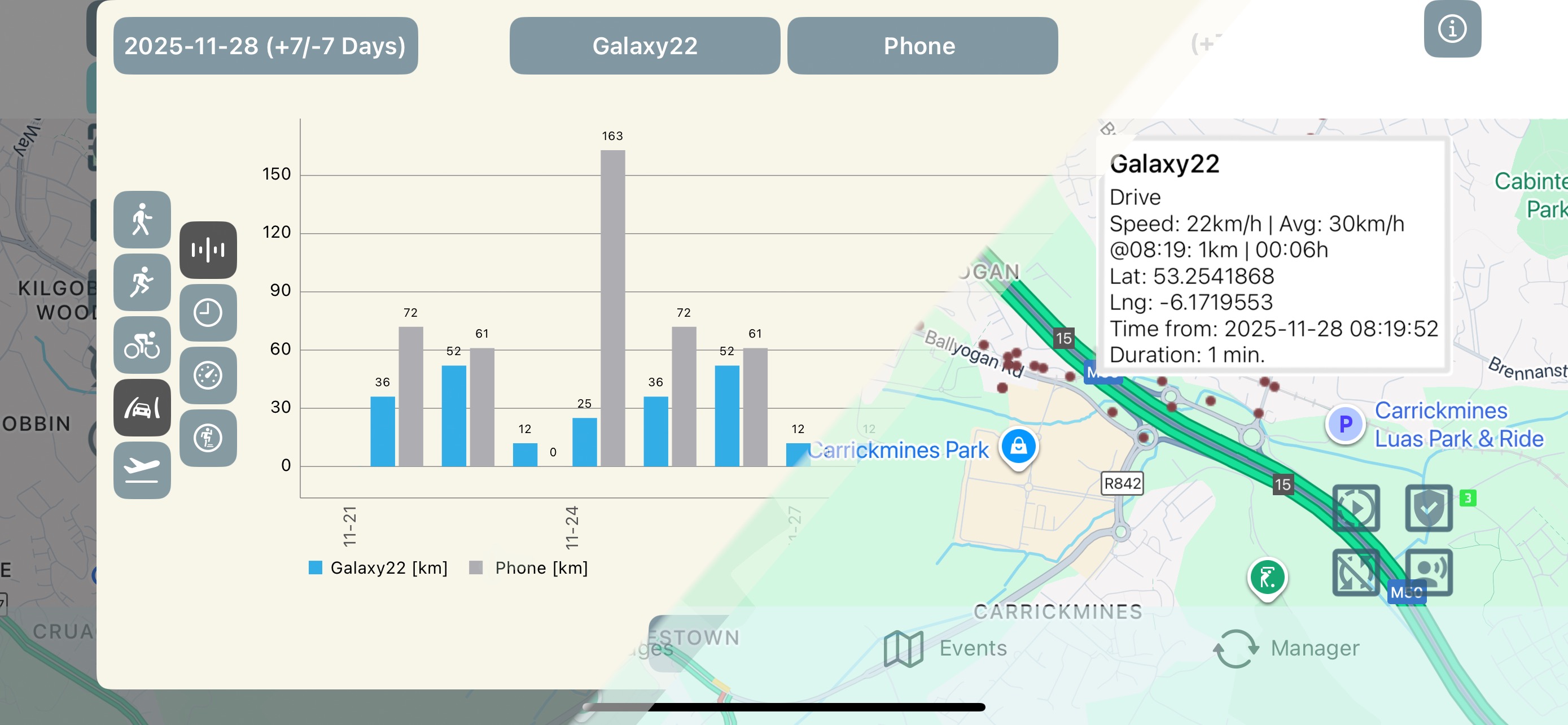
Activities provide valuable context beyond location alone.
Each recorded location is joined together with useful activity information such as:
• Walking
• Running
• Cycling
• Driving
• Flights
• Speed
• Distance travelled
• Step count
Activity history is particularly useful when reviewing your journeys, retraceing to understand previous events or assisting during rescue and search situations. You may also view the activities on charts.
Typical Use Cases
Be-Maps is designed for everyday coordination as well as unexpected situations.
People commonly use Be-Maps to:
• Know when family members arrive home safely.
• See where someone is while waiting to be picked up.
• Receive spoken notifications when children arrive at school.
• Receive reminders to visit important places.
• Monitor if someone is driving too fast.
• Receive notifications when someone becomes too far away.
• Navigate directly to another member using Google Maps.
• Review historical movements during rescue or search situations.
• Share alerts together with photos, videos and voice recordings.
• Review location history and activities to better understand previous events.
Why People Choose Be-Maps
Be-Maps is more than a location sharing application.
It combines private location sharing, intelligent GeoShapes, proximity monitoring, activity tracking and safety notifications into one integrated solution.
Families and trusted groups choose Be-Maps because it helps them:
• Stay connected without constant phone calls.
• Coordinate daily activities more easily.
• Improve awareness of each other's locations.
• Receive automatic spoken notifications.
• Share important information privately.
• Improve safety during everyday life and emergencies.
Privacy and Legal Notice
Privacy is one of the fundamental design principles of Be-Maps.
Unlike many location sharing applications, Be-Maps application does not store any of your personal data on our servers.
Your maps, locations, GeoShapes, activities, photos, recordings and alerts are exchanged directly between the devices belonging to your private Be-Maps Group using your own dedicated group email account.
This means, your data is stored only on devices that belong to your private Be-Maps Group, and is transferred via your private group email.
Be-Maps as a First Party:
• cannot view your locations or any of your date.
• does not have access to your devices.
• does not have access to your email account.
• does not have mechanisms to disclose your data.
The application also displays the current data-sharing mode in its notification area, so you always know how information your device can be shared.
Frequently Asked Questions:
What is Maps Sharing?
Maps Sharing is the core functionality of Be-Maps. It is much more than usual location sharing. It allows members of a private Be-Maps Group to securely share locations, activities, GeoShapes, event data, alerts and other map-related information directly between their own devices.
Is Be-Maps a location sharing app?
Yes. Be-Maps is a private location sharing application designed for families, friends and other trusted groups.
Who can see my location?
Only members of your private Be-Maps Group can view the information you choose to share. You may choose which data you want to share.
Can I stop sharing my location?
Yes. Depending on the selected data-sharing mode, you can temporarily suspend location sharing or switch to View Only mode.
Why does Be-Maps require background location?
Background location allows Be-Maps to monitor GeoShapes, generate proximity alerts, record location history and provide safety-related notifications even when the application is not open. Also it is needed for your safety, and situations when you need help.
What are GeoShapes?
GeoShapes are intelligent geofences that monitor important places, areas and routes. They generate spoken and visual notifications when selected users enter, leave or remain within monitored areas.
Does Be-Maps store my personal location data?
No. Your data is exchanged directly between devices in your private Be-Maps Group and remains under your control (at any time you can send automated delete request to remove your data from your group).
Can Be-Maps help during emergencies?
Yes. Members of your private group can quickly share their current location together with alerts, photos, voice recordings and videos. Location history and recorded activities can also help reconstruct events during rescue or search situations.
What makes Be-Maps different?
Be-Maps combines private location sharing, GeoShapes, proximity alerts, activity tracking, location history and privacy-first data sharing into a single application designed specifically for trusted private groups.